![]()
![]() SCENIC DRIVE
SCENIC DRIVE
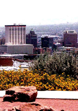
This is the best view of the city accessible by car, for one can see all of El Paso and Juarez. From downtown, take Stanton Street north and go right on Rim Road. The Rim Road neighborhood now has a beautiful sidewalk so visitors may take a stroll along one of El Paso's most gorgeous venues. Follow Rim Road all the way around the mountain and take a driving tour of Manhattan Heights, a lovely historic neighborhood.
Scenic Drive is the road that follows the rim of the Franklin Mountains, the lower tip of the majestic Rocky Mountains. Scenic Drive overlooks two countries, two states and two cities. This road attracts young and old as a tourist attraction and as a favorite site for natives, and it only cost $200,000! Impossible, you say? Well, today yes, but city fathers in the 1920s saw the future and created this wonder — Scenic Drive — for generations to enjoy. The beautiful Franklin Mountains and Scenic Drive have always fascinated El Pasoans, and the Franklins are unique for their location in the middle of the city. In 1921, W. E. Stockwell wrote, "The city of El Paso, Texas, in growing from an adobe village in 1900 to a city of over 80,000 people today, has spread around Mt. Franklin so that the point of the large mountain projects almost to the geographical center of the city." El Paso has grown so much since then, it's no longer the geographical center of the city, although the Franklins still divide El Paso into West and East sections. It is impossible not to admire the rugged crags of the Franklins whether one is flying in or out of the city or driving in any direction. Ninety+ years later, this mountain road is still a popular place to visit, as it was as soon as it was built. Mayor C. E. Kelly's administration enthusiastically supported the construction of Scenic Drive, and Kelly held a citywide celebration to encourage the plan. Tom Lea, candidate for the 1915 mayoral race along with Kelly, also backed the road's construction, as did Hughes D. Slater and George E. Kessler. Slater, the editor and owner of the El Paso Herald, led efforts to eliminate slums, build public parks and develop local points of interest. George E. Kessler referred to Scenic Drive as "mountain drive" when he wrote "The City Plan of El Paso, Texas." He felt strongly that "nothing of a permanent nature should be done here [on the Franklin Mountains] until funds are available for something worthy of the place and the city." Building Scenic Drive was no easy feat. The project began in March 1920 and was completed by the end of the year, with a chain gang helping on early construction of the road. More than a mile road was carved from solid rock on the slopes of Mt. Franklin; workers excavated more than 26,000 cubic yards of solid rock, 5,800 cubic yards of loose rock and 3,500 cubic yards of caliche. R. E. Hardaway, a civil engineer, was named the consulting and locating engineer for the mountain drive, while R. M. Dudley and W. E. Orr were hired as contractors. Dudley was in charge of the west side construction, while Orr took care of the east side. By the 1920s, more Americans of an expanding middle class owned automobiles and had the means to see the wonders of the nation, and the West with its mountains and spectacular natural beauty was fast becoming America's favorite playground. Records show that from 1907 to May 1913, El Pasoans registered 1,495 automobiles. Seating from two to five persons, these automobiles began to be used for recreational purposes. On October 6, 1920, the rough dirt road still under construction known as Scenic Drive formally opened for automobile traffic. During construction, the road was widened in places for cars to park so their occupants could enjoy the stunning view. Once completed, the road became very popular; historian W. H. Timmons noted that in the 1920's most El Paso citizens could afford automobiles to go to movie theaters and drive up to Scenic Drive on a "starry moonlit night." During construction, a brick wall was placed around the road to insure the safety of travelers. But the view was not entirely beautiful. At that time, travelers did not see beautiful, stately homes like those now lining Rim Road; before the construction of Scenic Drive, the area was known as Stormsville, and the city considered it a public health nuisance. D. Storms, a lawyer, owned a great deal of land along the rim where about 400 people lived in squalor. Stormsville had no water, electricity, gas, phones or sewers and only four toilets for all residents. Stormsville was torn down in 1928 when plans for the new Rim Road development were made. No one entering this area today could believe such a neighborhood existed in the same place. The paving of Scenic Drive occurred after it had been opened to the public. In 1932, the city contracted with J. C. Wright to grade and surface the road and over 4,000 tons of gravel were smoothed over it. Some funds for paving came from a Reconstruction Finance Corporation grant and the project employed many El Pasoans out of work during the Depression. Hartman says it cost around $87,000 to pave Scenic Drive, making the total cost of building of the drive less than $200,000. In February 1933, Scenic Drive reopened: "Streams of cars clogged the newly-paved road, and at 'Inspiration Point,' now Scenic Point, motorists honked their horns impatiently as they tried to move through the traffic jam," wrote Hartman. By 1933, 18,851 passenger automobiles were registered in El Paso County. Those who visit Scenic Drive today can see several markers and monuments at Scenic Point identifying historical and geographical points of interest. Two bronze markers honor the city officials who had the foresight to build the road and those who were responsible for paving it. In 1972, the city council raised a flagpole at Scenic Point honoring El Pasoans who lost their lives in World War II, the Korean War and the Vietnam War. Many young couples still visit Scenic Point as part of a romantic date, just like their parents and grandparents did. And just like in 1933 when the paved road was opened, sometimes drivers experience traffic jams on the mountain road, especially on weekend evenings. Tourists and natives alike use the coin-operated telescopes to magnify a particular view as they gaze out over two countries and the sparkling night lights. The narrow, winding road high above the city can terrify new drivers, but the views from Scenic Drive remain breathtaking, even in this jaded, technologically-oriented society. Not many cities have a mountain range right in the middle of their city, and still fewer have a spectacular drive around the rim of their mountains. El Paso has both. Hartman writes "If the pioneers who were responsible for Scenic Drive could stand at its apex on a clear evening, when millions of city lights are shimmering in the distance, their hearts would skip a beat or two at the marvels spread before them." |